CEPF is a joint initiative of l’Agence Française de Développement, Conservation International, the European Union, Fondation Hans Wilsdorf, the Global Environment Facility, the Government of Canada, the Government of Japan and the World Bank. A fundamental goal is to ensure civil society is engaged in biodiversity conservation.
Visitez le site français コア情報の日本語翻訳を読むOr use Google Translate to translate the English site to your language:
GTranslate

Working together for water and biodiversity: Roelie Kloppers of Wildlands Conservation Trust, Ntate Mbuyiseli Xingwana of ERS/Motseng community, and Dan Rothberg of the Critical Ecosystem Partnership Fund meet at Ntate Xingwana’s home in Motseng adjacent to the Ongeluksnek Nature Reserve, to discuss efforts to restore nearby grasslands that are under attack by invasive plants.
Photo by Nicky McLeod
Water, Biodiversity, Jobs: Eastern Cape & Kwazulu-natal
07 November 2017
07 November 2017
Overview
Mzimvubu River: Working together for water and biodiversity
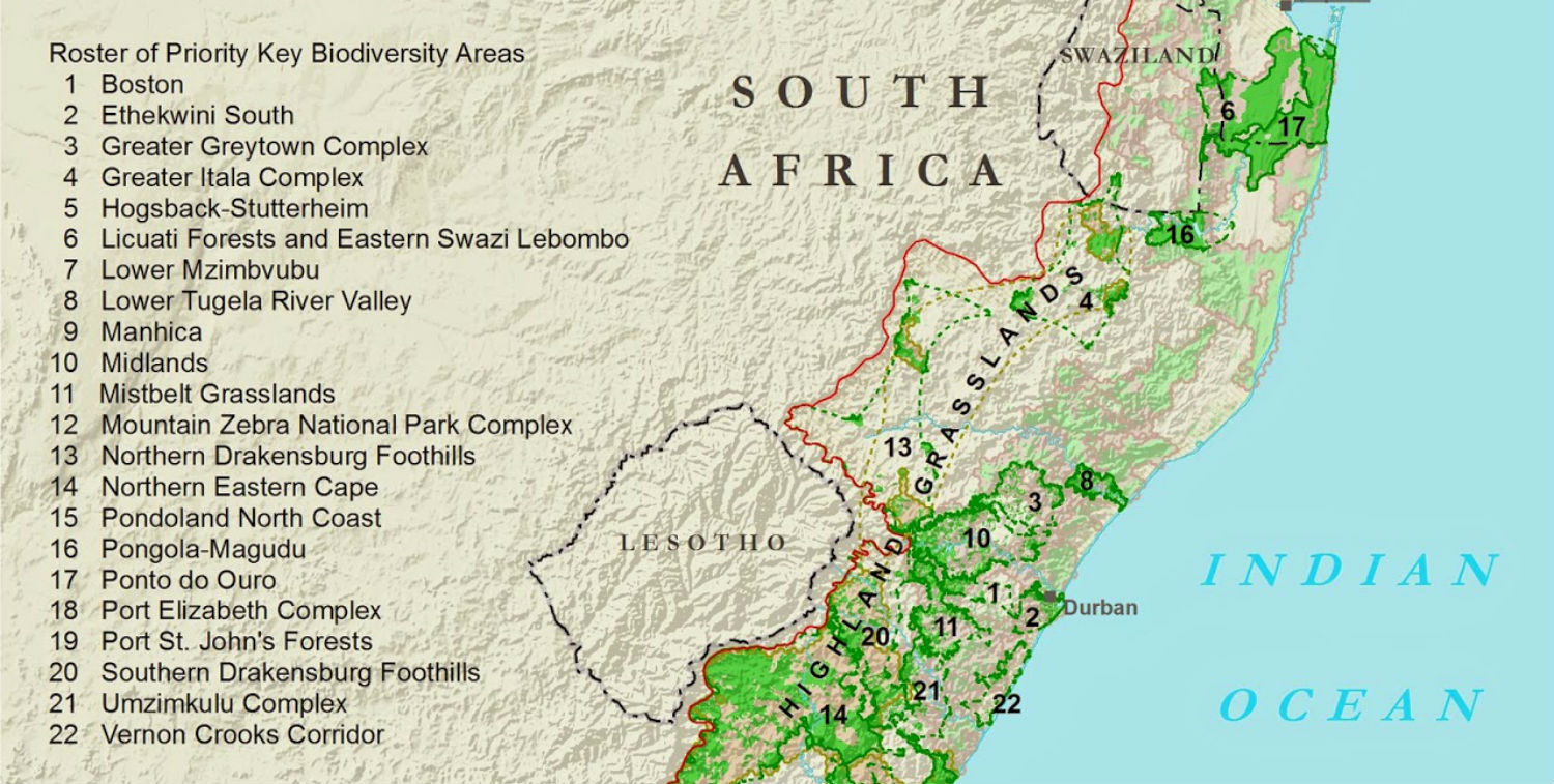
Running from the Drakensberg Mountains at the border with Lesotho to the Wild Coast at Port St. John's, the Mzimvubu River is one of the most important, and one of the last free-flowing, rivers in South Africa. The ecosystems that make up the river's catchment zone channel fresh water to the river and make that water available to 1 million human residents and the many, many other forms of life found here, inside one of the world's biodiversity hotspots. The Critical Ecosystem Partnership Fund (CEPF) is supporting multiple nongovernmental organizations (NGOs) in South Africa to improve the management of the Mzimvubu River catchment to ensure water quality and quantity for people and biodiversity.
See our CEPF Google Earth tour of projects in the Mzimvubu Catchment.
CEPF, Wildlands and the biodiversity hotspot
CEPF is a joint initiative of l’Agence Française de Développement, Conservation International, the European Union, the Global Environment Facility, the Government of Japan, the MacArthur Foundation and the World Bank. The Fund provides grants to and builds capacity of nongovernmental and private-sector organizations around the world that are working to help protect biodiversity hotspots—Earth’s most biologically rich, yet threatened, regions—and improve human well-being.
One of the hotspots where it has supported civil society and conservation is the Maputaland-Pondoland-Albany (MPA) Hotspot. It lies along the east coast of southern Africa, below the Great Escarpment, extending from extreme southern Mozambique (south of the Limpopo River) and Mpumalanga province in South Africa (south of the Olifants River) in the north, through eastern Swaziland to the Eastern Cape province of South Africa in the south.
South Africa's Wildlands Conservation Trust, based in Hilton, serves as CEPF's regional implementation team, making sure that CEPF's conservation strategy for the hotspot is implemented and working with CEPF grantees to strengthen the conservation community in the hotspot. One focal area of CEPF's investment in MPA is the Mzimvubu River Catchment.
Local Communities
Mapping it out from Matatiele
Matatiele is the town nearest the Motseng community that is working with CEPF grantees to improve management of the Mzimvubu River Catchment while gaining job opportunities and control over the land they reside on. Matatiele also hosts offices of CEPF grantees Environmental and Rural Solutions (ERS) and Conservation South Africa (CSA).
20131107041317.jpg
, Dan Rothberg (far right) of CEPF listens as (from right) Cobus Theron of the Endangered Wildlife Trust, Nicky McLeod of ERS and Joyce Loza of the Maloti Dr")
Caption:
Getting the big picture of the project: At the offices of Environmental and Rural Solutions (ERS), Dan Rothberg (far right) of CEPF listens as (from right) Cobus Theron of the Endangered Wildlife Trust, Nicky McLeod of ERS and Joyce Loza of the Maloti Drakensberg Transfrontier Programme (MDTP) review the territory and goals of the Mzimvubu River catchment conservation project.
Credit:
© CI/ photo by Julie Shaw
Rooting out invasives at Ongeluksnek Nature Reserve
Contributing to Convention on Biological Diversity Aichi Targets
CEPF grantees CSA and ERS are working with local communities and the local and provincial governments to improve management of the Mzimvubu River catchment, including in and around the Ongeluksnek Nature Reserve on the mountainous border with Lesotho. Improving management of the land includes employing local residents to remove invasive plant species and working with local communities to rotate livestock grazing areas, which allows native plants to reseed. A few of the results as of September 2014:
- Clearance of invasive wattle trees from 270 hectares.
- Improved long-term livelihood opportunities for 40 rural households through conservation-related jobs, grazing and tourism.
- Assistance to the nearby Motseng community to establish a communal property association allowing the citizen-run organization to take ownership 805 hectares of land adjacent to the reserve.
- Establishment of a grazing management program to improve livestock health and grassland cover and biodiversity.
20131107083646.jpg

Caption:
Working against invasive species: CEPF grantees greet community workers who have been removing invasive wattle trees near the reserve.
Credit:
© CI/ photo by Julie Shaw
20131107060604.jpg

Caption:
Ongeluksnek Nature Reserve: Ongeluksnek is a 13,000 hectare reserve made up of steep grasslands in the southern Drakensberg Mountains.
Credit:
© CI/ photo by Julie Shaw
20131107060640.jpg

Caption:
Admiring the grasslands: Roelie Kloppers of Wildlands Conservation Trust, CEPF's regional implementation team for the Maputaland-Pondoland-Albany biodiversity hotspot, looking out over Ongeluksnek.
Credit:
© CI/ photo by Julie Shaw
20131107060643.jpg

Caption:
In search of vultures: Community members and park rangers head toward planned location of a vulture hide, a shelter from which reserve visitors could watch vultures feed without disturbing them. Ongeluksnek is home to the Cape vulture and the bearded vulture.
Credit:
© CI/ photo by Julie Shaw
South-Africa-Ongeluksnek_preview.jpg

Caption:
On the front lines of the invasion: On a hillside near Ongeluksnek, with branches of invasive wattle trees overhead, CEPF Grant Director Dan Rothberg, at left, talks with the team removing these invasive trees that choke out native species.
Credit:
© CI/ photo by Julie Shaw
944x514_ci_94954169_Medium.jpg

Caption:
Cape vulture
Credit:
© Tessa Mildenhall
Working with ranchers in Cedarville
Contributing to Convention on Biological Diversity Aichi Targets
An important piece of the water catchment management puzzle is private landowners. A CEPF small grant to the Cedarville Conservancy, a group of landowners in the Cedarville area of the Eastern Cape, encouraged rotational grazing to allow native grasslands to recover between grazing periods. These grasslands are key to preventing soil erosion while promoting water flow to the Mzimvubu River. The Cedarville conservancy has joined the Provincial Biodiversity Stewardship Programme and will be proclaimed as a protected environment in due course. A Protected environment is a legally recognized category of environmental protection that acknowledges farming activities as well as areas in these landscapes that have conservation value.
201311080239051.jpg

Caption:
Balancing livestock and biodiversity: Rancher Rob Rawlins and CEPF's Dan Rothberg, each holding map, discuss the rancher's management plan, which protects the diversity of plant life on his farm while maintaining his livestock. Rob is the chairperson of the Cedarville Conservancy, a voluntary group of landowners in the Eastern Cape who are supported by CEPF in their efforts to maintain plant biodiversity while operating successful ranches.
Credit:
© CI/ photo by Julie Shaw
944x451_20131108063421.jpg

Caption:
The view from Cedarville: The landscape near Cedarville as seen from a hill on Rob Rawlins’ ranch.
Credit:
© CI/ photo by Julie Shaw
Cranes and Wetlands
Conserving cranes in the Southern Drakensberg and East Griqualand
Contributing to Convention on Biological Diversity Aichi Targets
CEPF is providing support for wattled cranes (Bugeranus carunculatus) through a project implemented by the Endangered Wildife Trust (EWT) focusing on the cranes' breeding grounds in the Eastern Cape and Kwa-Zulu Natal provinces. The project involves a landowner-driven effort to sustainably manage grasslands and build a corridor of sustainably managed natural areas connecting the Swartberg area of the southern Ukhahlamba World Heritage Site west along the watershed of the Mzimvubu to the Ongeluksnek Nature Reserve.
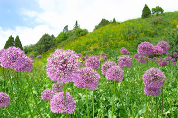
20131108064439.jpg

Caption:
Wildflowers: Wildflowers are plentiful on the property of Francois Talbot, who has signed his property over as a Nature Reserve, and this in turn is catalyzing adjacent land owners to rethink their stewardship management approaches.
Credit:
© CI/ photo by Julie Shaw
20131108071215.jpg

Caption:
Wildflowers II: Another wildflower enjoying the sun on a hilltop. The communal land below the ridge to the south, Mzongwana, is embarking on a range restoration program involving alien clearing and managed grazing, based on expansion of the lessons learned at Ongeluksnek.
Credit:
© CI/ photo by Julie Shaw
20131108071121.jpg

Caption:
OK, so I like flowers: A flowering bush takes in the sun a steep hilltop.
Credit:
© CI/ photo by Julie Shaw
20131108071031.jpg

Caption:
On edge: Ian Worrall, seated at right, hotel owner, St. Bernard's Peak Lodge in Swartberg, looks out over Talbot's property. He and Talbot are among those working with EWT to ensure sustainable management of natural areas on their properties and beyond.
Credit:
© CI/ photo by Julie Shaw
944x501_20131108072920.jpg

Caption:
The big picture: Landowner Francois Talbot talks with Nicky McLeod of ERS about the management of his land.
Credit:
© CI/ photo by Julie Shaw
Protecting vital wetlands at Penny Park, Kokstad
Contributing to Convention on Biological Diversity Aichi Targets
The Penny Park Wetland near the town of Kokstad in KwaZulu-Natal Province is another of the sites where EWT is working with landowners on land use management. During dry periods, the 147 hectare wetland is a key source of water for Kokstad, with a population of more than 50,000, and other downstream residents. The wetland areas are under private ownership. Wattled cranes breed here, and a variety of other bird species can be found in Penny Park as well. Damaged by draining and diversion of a feeder stream, the wetland has benefited from recent government-funded rehabilitation efforts, and breeding prospects for many species in the area have improved. The EWT also has catalyzed support for the creation of a tourism experience at the wetland.
20131108101237.jpg

Caption:
Reflecting on wetlands: Evening sun reflects off water in Penny Park.
Credit:
© CI/ photo by Julie Shaw
20131108101346.jpg

Caption:
Touring Penny Park: Joyce Loza of MDTP, left, talks with Cobus Theron of EWT and Roelie Kloppers of Wildlands Conservation Trust, while Nicky McLeod of ERS and Sinegugu Zukulu of CSA share thoughts on the wetland.
Credit:
© CI/ photo by Julie Shaw
20131108101626.jpg

Caption:
The long view: Wildflowers brighten the grasslands in and around Penny Park.
Credit:
© CI/ photo by Julie Shaw
Forest and River
Engaging communities – Ntsubane Forest
Contributing to Convention on Biological Diversity Aichi Targets
20131109033152.jpg

Caption:
Protecting their forest resources: Members of the Participatory Forest Management Committee of the Goso community gathering near a patch of forest they have been working to restore by removing alien plants species and replacing them with native trees and plants.
Credit:
© CI/ photo by Julie Shaw
A forest patch at the village of Goso in the Eastern Cape is part of the Ntsubane Forest Complex, the largest remaining indigenous forest complex on the Wild Coast of South Africa. CEPF grantee Wildlife and Environment Society of South Africa (WESSA) is working with local communities, the Eastern Cape Parks and Tourism Agency and the Wild Coast Forest Users Association to improve management of these forests and help communities develop sustainable livelihoods that do not deplete their natural resources.
Through the CEPF-funded project, WESSA engaged communities to clear 60 hectares of invasive alien plants, trained 36 people in removal of invasives and forest rehabilitation, trained 10 people in alternative livelihoods, and improved the capacity of 1,000 youth to undertake local conservation biodiversity projects. In 2013, CEPF provided additional funds to expand the program.
20131109033159.jpg

Caption:
Community-driven conservation: Three communities in the Nsubane Forest Complex--Dedeni, Khaleni and Goso--were engaged by WESSA for its first project with CEPF.
Credit:
© CI/ photo by Julie Shaw © CI/ photo by Julie Shaw
20131109033330.jpg

Caption:
Rebuilding the forest: A patch of forest in Goso from which community members removed alien plants and replaced them with native plants.
Credit:
© CI/ photo by Julie Shaw
20131109044456.jpg

Caption:
Reliant on healthy ecosystems: Many people in the area rely on subsistence farming and the use or sale of forest products to support themselves.
Credit:
© CI/ photo by Julie Shaw
20131109045918.jpg

Caption:
Lupatana Gorge: A project site where large invasive alien plants have been cleared and used by the community as fuel wood.
Credit:
© CI/ photo by Julie Shaw
20131109050425.jpg

Caption:
Gilding the gorge: Erica junonia plant at edge of gorge.
Credit:
© CI/ photo by Julie Shaw
20131109052240.jpg

Caption:
A pretty place to graze: Livestock of nearby residents graze near the gorge.
Credit:
© CI/ photo by Julie Shaw
20131109052744.jpg

Caption:
The gorge's waterfall: Mgawa Falls
Credit:
© CI/ photo by Julie Shaw
20131109052759.jpg

Caption:
Better than meeting at the office: Laura Conde of WESSA and CEPF Grant Director Dan Rothberg discuss WESSA's activities.
Credit:
© CI/ photo by Julie Shaw
20131109055222.jpg

Caption:
Protecting valuable resources: Maintaining the surrounding forests also helps protect the quality of the water flowing through it.
Credit:
© CI/ photo by Julie Shaw
River meets sea at Port St. Johns
View of the Mzimvubu reaching the Indian Ocean at Port St. Johns.


